Ancient landslides: really inactive?
Faculty of Science UHK
Project Description
The recent activity of ancient landslides is often unknown or supposed as low to none. The lack of data about their activity can even lead to fatal underestimation of landslide hazards because small-magnitude movements often precede their catastrophic reactivation. The long-term monitoring of landslide movements is usually necessary for the determination of the recent activity of ancient landslides. This project solves the possibility of recent activity estimation without monitoring. The combination of tree-ring-based (dendrogeomorphic) methods with the data from several monitored landslides (reference) will create the calibrated approach for application on unmonitored landslides with unknown activity. Moreover, the developed approach will benefit from data about the depth and inner structure of landslides from geophysical measurements (the three most common methods: ERT, GPR, and SSR). Deep-seated gravitational landslides will be the only type of studied landslides. The developed approach will be applied to unmonitored landslides to test the possibility of regional estimation of landslide hazard.
Detailed information
The general concept of the project is to analyse the hypotheses about the generally supposed prevailing (in)activity of old/ancient landslides. As seemingly inactive landslides can be catastrophically reactivated, this question is of the top interest regarding natural hazards assessment. Recent activity of ancient landslides can reach only several mm to cm per year and without long-term monitoring is not detectable. Nevertheless, this project aims to use tree-ring-based methods for verification/falsification of recent activity of seemingly inactive ancient landslides. As known, tree-ring-based methods are able to detect landslide movements even with a magnitude of several mm. Nevertheless, verification or calibration of this approach has not yet been done. An important variable influencing the tree-ring record is the type and particularly the inner structure of the landslide. Fortunately, geophysical methods provide sufficient data for the detailed determination of landslide inner structures. The best results are obtainable when various types of geophysical methods are used.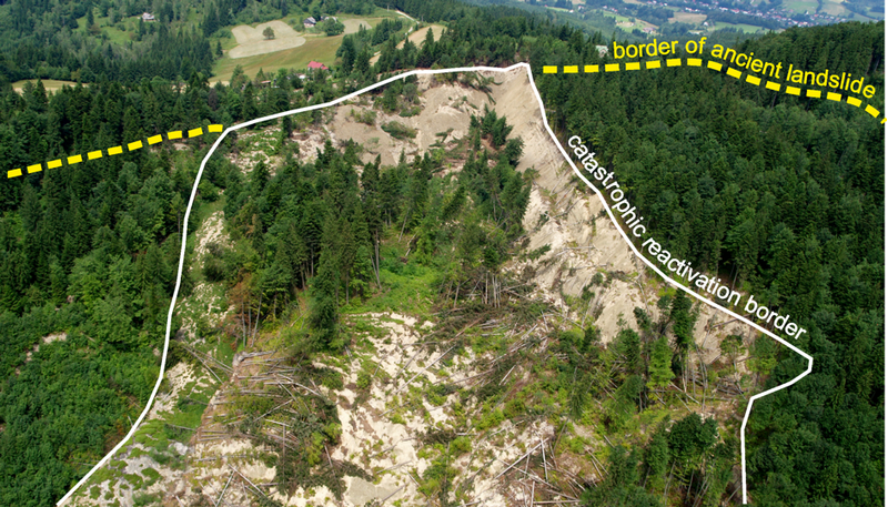
Moreover, various types of landslides behave in a different way, express different inner structures, and induce different tree-ring evidence. Thus, this project is strictly focused on one type of landslide: deep-seated rotational landslides. The reason for this choice is the following: (i) it is an abundant type of landslide occurring in the great part of the world, (ii) it can be catastrophically reactivated, and (iii) it expresses distinct morphology to be clearly determined in the field.
Regarding the above-mentioned facts, the structure and aims of the project constitute from the following steps:
- The calibration of dendrogeomorphic (tree-ring-based) methods using data from long-term field instrumental monitoring. This analysis will be realized on three monitored “reference landslides”.
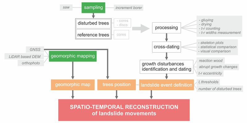
- Comparison of tree-ring-based data with the inner structure of reference landslide. Various geophysical approaches will be applied to this.
- Complementation of obtained points of knowledge and the development of methodology for the analysis of ancient landslides' recent activity. The methodology supposes a multidisciplinary approach based on a combination of dendrogeomorphic and geophysical methods.
- The application of the developed methodology to six large landslides without monitoring (landslides of the same type, large landslides, possibly representing the hazard for neighbour infrastructure). Two possible opposing results are expectable from this step: (i) verification of landslide inactivity, or (ii) determination of various degrees of landslide activity. Both types of results contribute to a more accurate landslide hazard assessment.

Project supervisor
Section navigation: Topics
